
Initial ACD Workshop
Report of an International Workshop: Marine Biological Laboratory Woods Hole, Massachusetts, November 2-4, 1999
Summary
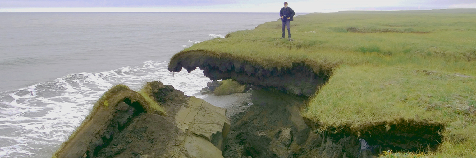
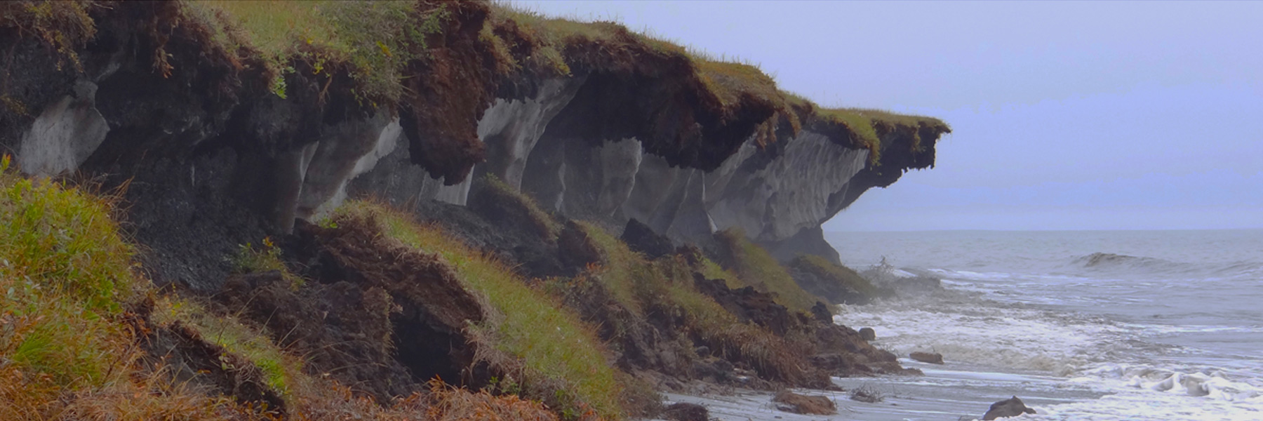
The circum-Arctic coastal margin is about 200,000 km long and is the interface through which land-shelf exchanges are mediated. Sediment input to the Arctic shelf resulting from erosion of ice-rich, permafrost-dominated coastlines may be equal to or greater than input from river discharge. In addition, climate change in the Arctic is predicted to be more rapid and more intense than at lower latitudes. Determining sediment sources and transport rates along high latitude coasts and inner shelves is critical for interpreting the geological history of the shelves and for predictions of future behavior of these coasts in response to climatic and sea level changes. In order to address these and methodological issues, a workshop was held in Woods Hole, Massachusetts, November 2-4, 1999, and attended by 45 participants from Canada, Germany, Russia and the United States. The workshop's primary sponsor was the NSF's Office of Polar Program and its program "Russian-American Initiative on Shelf-Land Environments" (RAISE).
Objectives: Workshop objectives were developed in a series of pre-workshop planning meetings:
-
Develop and apply a classification system for coastal mapping and for assessing the sensitivity and erosion potential of Arctic coasts.
-
Identify, describe and recommend techniques applicable for use in mapping and measuring erosion and accretion.
-
Identify critical processes that affect dynamics of high latitude shorelines.
-
Develop estimates of erosion rates for representative circum-Arctic coastlines.
Accomplishments
Following the first day of invited presentations and posters, workshop participants divided into small breakout groups. Results and conclusions of these deliberations were:
-
Classification and Mapping: Development of a consistent and generalized classification for high-latitude coasts is essential for development of circum-Arctic databases and maps. An acceptable classification must be broad enough to encompass existing schemes while capturing fundamental information for assessment of climate change impacts and coastal processes. A physical classification scheme was developed based on morphology and materials, and specific regions were identified for prototype mapping assessment.
-
Coastal Processes: In high latitudes, both ground ice in permafrost and sea ice have dramatic influences on sediment transport and coastal change. The primary forcing parameters for coastal change in the circum-Arctic regions and methods for compilation of environmental parameters were enumerated.
-
Ground-ice Estimates and Mapping: Massive bodies of ground ice occupy large volumes of onshore permafrost and facilitate rapid transgression of coasts. Consensus was reached on direct and indirect methodologies for estimating ground ice volumes and presentations of data on maps.
-
Monitoring and Site Requirements: Spatial and temporal changes in beach and nearshore morphology and rates of erosion are critical to our understanding of processes and trends. A suite of standard tools and techniques were agreed upon for development of long-term coastal monitoring sites measurement, including metadata required for the selection and establishment of key monitoring sites and direct involvement of local communities.
Recommendations
Workshop participants approved the following:
-
High-latitude coastlines, dominated by cryological processes, are sensitive to climate variations, and therefore, the associated coastal impacts and adaptations should be appropriately recognized in the forthcoming Third Assessment Report of the Intergovernmental Panel on Climate Change (IPCC) and by national and international organizations.
-
A concerted and coordinated international data synthesis and mapping effort is required to properly assess the magnitude of sediment derived and transported from the coast onto the shelf.
-
An international network of representative key and observational sites is required for assessing long-term changes, including threats to local communities, habitat modifications, and carbon and sediment budgets, etc.
-
A local community-based monitoring protocol should be part of an international design with observations conducted by Arctic residents.
-
There is a need to prepare a synthesis of existing data and information concerning fluvial sediment inputs to the Arctic shelves and basins.
Future Activities
International planning, cooperation and funding of national, bilateral and multi-national projects are required to accomplish the following:
-
Develop a circum-Arctic monitoring network of key and observational sites based on a metadata inventory of potential regional sites.
-
Construct databases for web-based delivery.
-
Apply the coastal classification to representative sites.
-
Develop circum-Arctic map products of coastal sediment yields, climate change sensitivity, severity of environmental forcing, etc.
-
Explore and develop international cooperation and projects with other organizations including the International Arctic Science Committee (IASC), Intergovernmental Oceanographic Commission (IOC), International Hydrographic Organization (IHO), IGBP-Land-Ocean Interaction in the Coastal Zone (LOICZ), Arctic Paleo-Discharge (APARD), IGU), and IGU commissions.
-
Convene workshops periodically to assess progress and facilitate the development of specific activities.
Information available
Posters highlighting the workshops accomplishments were presented at the Laptev Sea conference in St. Petersburg, Russia (November 26-28,1999) and at the AGU Fall Meeting in San Francisco (December 13-17,1999). These posters will be presented at other meetings in 2000 to inform individuals and organizations of the present status and future directions of the Arctic Coastal Dynamics initiative. A final workshop report is in preparation. For additional information contact Jerry Brown, the workshop convenor, on behalf of the International Permafrost Association (IPA) and its Coastal Erosion Subgroup.