
Arctic Coastal Dynamics 4th Newsletter
February 2003
The main purpose of the ACD Newsletter is to inform you as an Arctic researcher interested in coastal dynamics about the progress and activities of the IASC-IPA project Arctic Coastal Dynamics (ACD). The third Newsletter was sent out in April 2002 and this fourth Newsletter summarizes the achievements of the last months and the future activities.
1 Achievements since April 2002
1.1 Field work in 2002
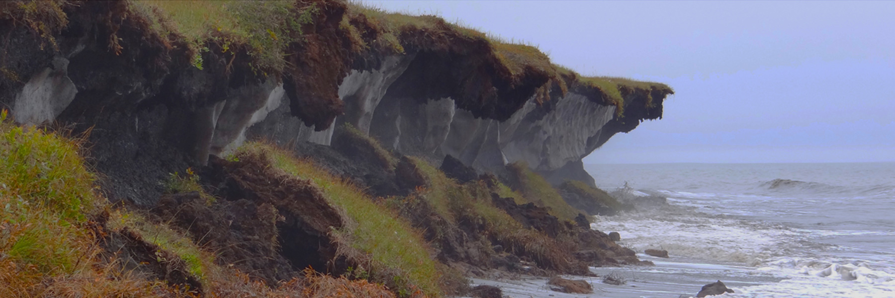
Barents and Kara Sea: Onshore and offshore observations were conducted at the three key sites. Detailed tacheometric survey of the thermoerosional coast with precise fixation of the coastal scarp top and other morphostructures was carried out at the Kara Sea site. The survey of the shore line and offshore profiling were performed at the new established key site on the north-western coast of the Kolguev Island (Barents Sea).
Laptev and East Siberian Sea: Within the Russian-German bilateral cooperation coastal fieldwork was performed around the New Siberian Islands organized by the Potsdam Branch of the Alfred Wegener Institute, the Permafrost Institute (Yakutsk), and the Arctic and Antarctic Research Institute (St. Petersburg). At several locations along the coastline of the Archipelago coastal sections were studied in regard to morphology, composition and dynamics.
Beaufort Sea (US and Canada): Bluff recession and elevations were measured at several U.S. Beaufort key sites and relative water levels were recorded at the Elson Lagoon sites during late summer. Coastal field work was undertaken in the west-central portion of the Canadian Arctic in the vicinity or the communities of Kugluktuk (Nunavut), Holman (Northwest Territories), and Sachs Harbour (Northwest Territories) and in other locations on Banks Island. The investigations involved coastal mapping using aerial videography, GPS-based vertical motion studies, coastal process investigations and validation for remote sensing. The work was performed by the Geological Survey of Canada (Natural Resources Canada) in collaboration with the Geodetic Survey of Canada, the Canadian Wildlife Service, and the University of Northern British Columbia.
Spitsbergen: Four sites for measuring coastal cliff erosion by the use of terrestrial photogrammetry were established in the Kongsfjorden area around Ny-Ålesund at Spitsbergen (79˚ N, 13˚ E) in the period of August 2nd to 8th 2002. At each site photographs were taken from two to three different camera positions to be able to construct threedimensional terrain models of the cliffs by using digital photogrammetry. The plan is to photograph the sites again in two years time and to construct a new set of digital terrain models. The erosion rate can be found by simply taking the difference between these two sets of terrain models. Due to the short distance between camera and cliff (7-15 m), the accuracy is in the millimeter range.
1.2 Third ACD workshop, Oslo (Norway), 2-5 December 2002
The third IASC-sponsored ACD workshop was held in Oslo, Norway, on December 2-5, 2002. Participants from Canada (3), Germany (3), Great Britain (1), the Netherlands (1), Norway (6), Russia (11), Switzerland (1) and the United States (2) attended. Of these five were young scientists supported by IASC. Two current INTAS projects provided support for six additional Russian participants. The Geography Department at the University of Oslo organized the local logistics for the workshop. The objective of the workshop was to review the status of ACD according to the Science and Implementation Plan, with the main focus on the quantitative assessment of the sediment and organic carbon input to the Arctic Ocean through coastal erosion. During the first part of the workshop, 29 papers dealing with regional and/or circum-Arctic coastal dynamics were presented. Based on the material presented, three regional working groups and two circum-Arctic working groups were organized. The main task of the regional working groups was to continue previous efforts to segment and classify the coast for their sectors. The coastal segmentation and classification is the basis for the assessment of the sediment and organic carbon input through coastal erosion (the refined classification is available on the ACD web page). Additionally, representative photographs of coastal sites for each sector were selected for inclusion in a coastal photo library (see below under products). The circum-Arctic working groups focused on GIS development and extraction and presentation of environmental data, respectively.
Western Russian Arctic (Barents and Kara Sea) WG
Leader: A. Vasiliev Participants: D. Drozdov, A. Kizyakov, D. Pertednya, I. Streletskaya, S. Ogorodov, F. Rivkin and A. Vasiliev
The segmentation of the coastline in the western Russian Arctic was almost completed during the workshop. The final version of the segmentation and classification of the entire western Russian Arctic will be available at the next ACD workshop (November 2003, see below).
Eastern Russian Arctic (Laptev, East Siberian and Chukchi Sea) WG
Leader: M. Grigoriev Participants: F. Are, M. Grigoriev, H.-W. Hubberten, V. Ostroumov and V. Rachold
The segmentation of the Laptev Sea coast is practically finished, but the western segments have to be revised. For the East Siberian Sea 50-60 % of the coastline could be segmented, the segmentation of the remaining parts will be completed by middle of 2003. A first approximation of the segmentation was performed for the coastline of the Chukchi and a detailed segmentation is anticipated no later than the next ACD workshop.
Canadian and Alaskan Beaufort Sea WG
Leader: S. Solomon Participants: J. Brown, A. Mahoney, H. Lantuit and S. Solomon
Much of the Canadian Beaufort Sea coastal segmentation and classification had been accomplished at a meeting in Bremerhaven in October 2002. M. Grigoriev, J. Brown, S. Solomon, W. Pollard (McGill University, Montreal, PQ, Canada) and V. Rachold participated in the October meeting which was funded in large part by the Canadian Department of Foreign Affairs and International Trade. Segmentation of the southern part of the Arctic Islands Archipelago (Banks Island) is underway as part of coastal vulnerability assessments in Canada and is expected to be completed by May 2003. The remainder of the Archipelago will be undertaken in conjunction with colleagues working on the Greenland coasts (Ole Humlum and Hanne Christiansen). The U.S sectors of the Beaufort and Chukchi seas have been divided initially into 45 and 15 segments, respectively, and largely follows subdivisions made in earlier studies. Further refinements in the segmentation will be made as the classification is reviewed and completed.
Environmental WG
Leader: D. Atkinson (financed through the IARC grant “Analysis of Coastal Meteorological and Oceanographic Forcing in the Arctic Basin”)
Participants: D. Atkinson, J. Hölemann and A. Mahoney
The Environmental Working Group (EWG) discussed which environmental data should be included for output, how and in what time and spatial scales should the output be delivered, and what additional information is required to complete the output items. To become acquainted with what the field researchers consider of importance the EWG members met with the regional WGs. Additionally, the EWG output was discussed with the GIS WG to be consistent with the requirements and constraints of the final GIS structure. Various elements have been selected as relevant to the aims of the ACD project and will be output to the GIS. The first round will include basic meteorological elements as expressed in the form of various derived statistics. The second round will consist of process or temporal model results. Final output form will be in GIS layers, or in a format specified by the GIS technical personnel, delivered directly to the ACD secretariat.
GeoInformation System (GIS) WG
Leader: R. Ødegaard
Participants: D. Atkinson, D. Drozdov, B. Etzelmüller, H. Lantuit, I. May, V. Rachold, F. Rivkin, F. Steenhuisen and B. Wangensteen
It was decided that the ACD coastal segmentation database will be stored in the PANGAEA system (http://www.pangaea.de), which is the core database for “raw” data needed in the calculations of sediment and organic input. For analyses and other scientific purposes within the project the raw data will be exported from this system into different GIS and other processing software. To link the tabular data in PANGAEA to the World Vector Shoreline (WVS) a small web-based front-end to the PANGAEA system, which is based on the ArcIMS software, will be developed. The GIS development will be supported by the UNEP- World Conservation Monitoring Centre (Cambridge, UK) and the Arctic Center (Groningen, Netherlands), which are new participants in ACD. The defined regional experts will have the permission to carry out the segmentation for a predefined sector of the coastline.
A report of the 3rd Workshop including a detailed summary and the extended abstracts will be published in “Reports on Polar and Marine Research”.
1.3 Publications and products
- A report of the 2nd ACD Workshop (Potsdam, 26 - 30 November 2001), including 25 extended abstracts, was published in a special issue: Rachold, V., Brown, J. & Solomon, S. (2002): Arctic Coastal Dynamics - Report of an International Workshop, Potsdam (Germany) 26-30 November 2001. Reports on Polar and Marine Research 413, 103 pp.
- A number of ACD relevant papers were accepted for a special session and publication in the Proceedings Volume of the 8th International Conference on Permafrost (Zurich, Switzerland, 21 - 25 July 2003).
- Several other ACD related papers have been published, a publication list, which will be frequently updated, is available at the ACD web page.
- The second version of the CAPS-CD (Circumpolar Active-Layer Permafrost System) will be completed for distribution at the 8th International Conference on Permafrost in July 2003. The following ACD products, which are available at the ACD web site as well, will be submitted:
o Russian bibliography of ACD related literature containing ca. 550 references;
o ACD metadata for key sites;
o Library of circum-Arctic coastal photographs of the ACD key sites and additional coastal sites containing ca.
120 photographs.
1.4 Conference presentations since April 2002
Members of the Steering Committee met during the annual conference of the Russian permafrost community in Pushchino, May 2002, and participated in a special ACD session. Additional ACD presentations were given at
- Arctic Science Summit Week (Groningen, Netherlands, 21-27 April 2002);
- Climate Drivers of the North (Kiel, Germany, 8-11 May 2002);
- 5th International Workshop “ Land-Ocean Interactions in the Russian Arctic” (LOIRA) (Moscow, Russia, 12-15 November 2002).
2 Activities in 2003
2.1 ACD related field work in 2003
Barents and Kara Sea: The observation of coastal dynamic at the three key sites will be continued by VNIIOkeangeologia and other teams. The mapping of the present shore line position and offshore survey (including seismoacoustic and sonar profiling as well as bottom sampling down to the 50m isobath) will be performed.
Laptev Sea: A coastal pre-site survey at “Mammont Klyk” in the western Laptev Sea will be carried out by a Russian-German team during spring and summer 2003. The location “Mammont Klyk” had been selected as a site for a permafrost drilling transect planned for 2004.
Three key transects, located in the Kara, Laptev and East Siberian Seas, will be sampled during the summer activities in 2003 with regard to detailed organic carbon studies to improve our understanding of the fate of eroded organic material.
Beaufort Sea (US and Canada): Annual measurements at U.S. Beaufort and Chukchi key sites are planned.
Field work planned for 2003 in the Canadian Arctic includes:
1. A spring program (Geological Survey of Canada - GSC) to sample ice in the Mackenzie region of the Beaufort Sea as a follow up to reports of a freezing storm just prior to freeze up in 2002.
2. Summer field work (GSC) to the west and west-central Canadian Beaufort Sea to investigate vertical ground motion and coastal processes in the vicinity of communities to ascertain their vulnerability to climate change; measurements at established coastal sites and key sites will also be undertaken.
3. McGill University plans field work to Herschel Island to investigate coastal permafrost processes and applications of remote sensing.
4. Although not strictly ACD activities, it is worth noting that the multinational Canadian Arctic Shelf Exchange Study (CASES) will be initiating a major field campaign to study carbon cycling over the Beaufort Sea Shelf (http://www.giroq.ulaval.ca/cases/); in addition, a 2 month cruise will be undertaken by the Department of Fisheries and Oceans, the Fisheries Joint Management Board, and Natural Resources Canada to collect multibeam data for seabed geohazard investigations, granular resource assessment and habitat mapping.
2.2 Forthcoming ACD relevant meetings
- ELOISE (European Land-Ocean Interaction Studies), Gdansk (Poland) 24-27 March 2003: ACD presentation by V. Rachold.
- Arctic Science Summit Week, Kiruna (Sweden), 31 March - 4 April 2003: ACD presentation at the IASC Council meeting by V. Rachold (and poster).
- Arctic Workshop, Tromsø (Norway), 3-5 April 2003: ACD poster.
- EGU/AGU (European Geophysical Union / American Geophysical Union), Nice (France), 6-11 April 2003: ACD poster.
- Annual geocryology conference, Pushchino (Russia), 19-21 May 2003: ACD presentation by V. Rachold, Meeting of the ACD INTAS teams.
- 8th International Conference on Permafrost, Zürich (Switzerland), 21-25 July 2003: special session on coastal permafrost, a number of ACD papers, and distribution of the Oslo workshop report to conference participants.
- ICAM (Arctic Margins Meeting), Halifax (Canada), 30 September - 3 October 2003: special session on Arctic Margins: Coastal and Marine Environmental Geosciences in a Changing Climate; Implications for Development chaired by S. Solomon and L. Johnson (ACD poster and presentation).
2.3 Next ACD workshop
It was decided to organize the 4th ACD Workshop in St. Petersburg (Russia), November 2003, ideally to take place at about the same time as the WCRP Arctic Climate System Study (ACSYS) Final Conference and the Climate and Cryosphere (CliC) meeting. Georgy Cherkashov, VNIIOkeangeologia, has received permission to host the workshop. The status of ACD will be reviewed and the tasks for the next phase of the five-year plan will be developed. In particular, the Steering Committee decided to expand the scope of ACD to cover human aspects and the impact of coastal dynamics on habitats and species. Additional participants to cover these aspects including participants representing AMAP, CAFF, ACIA, LOIRA, LOICZ, WCMC and HARC will be considered based on IASC recommendations.
3 Financial support
Financial support by the following organizations is highly appreciated:
- International Arctic Sciences Committee (IASC);
- International Permafrost Association (IPA);
- Canadian Department of Foreign Affairs and International Trade (DFAIT) - CanadaGermany agreement;
- INTAS (International Association for the promotion of co-operation with scientists from the New Independent States of the former Soviet Union): project numbers INTAS Open Call 2001-2329 and INTAS Open Call 2001-2332;
- International Arctic Research Center (IARC): grant “Analysis of Coastal Meteorological and Oceanographic Forcing in the Arctic Basin”.
Volker Rachold
ACD Secretariat
Alfred Wegener Institute for Polar and Marine Research
Research Unit Potsdam
Telegrafenberg A43, 14473 Potsdam, Germany
http://www.awi-potsdam.de/www-pot/geo/acd.html